STATE MITIGATION PLANNING
The Cal OES State Mitigation Planning Unit (SMP Unit) is responsible for the maintenance, implementation, and update of California’s State Hazard Mitigation Plan (SHMP or Plan). The SMP Unit works with numerous subject matter experts to develop the SHMP and to track progress toward the SHMP’s defined mitigation goals. The SMP Unit also socializes the SHMP to stakeholders statewide to raise awareness about the Plan and about how it can be used for other planning efforts.
Contact the State Mitigation Planning Unit at SHMP@CalOES.ca.gov
NEW: Check out our translated documents in 8 languages!
2023 State Hazard Mitigation Plan (SHMP)
The SHMP is California’s primary hazard mitigation guidance document and demonstrates the State’s continued commitment to a comprehensive mitigation strategy. The SHMP:
-
- Details California’s historical and current hazards
- Identifies mitigation strategies and actions to address those hazards
- Provides guidance to local jurisdictions developing their own hazard mitigation plans.
The 2023 Plan update expands on previous SHMP discussions of hazard impacts on equity priority communities and of climate change as a hazard exacerbator. It also organizes hazards according to an impact rating, rather than by hazard type as seen in previous plans. The 2023 SHMP will expire on August 29, 2028. The Plan is split into two volumes to support clarity and accessibility.
Volume 1: Core Plan
Volume 1 is the Core Plan and profiles the hazards California faces, documents the State’s hazard mitigation program, and describes existing and proposed actions to mitigate the risk of those hazards.
Part 1 – Background Information
Part 2 – Profiles and Risk Assessments for Natural Hazards of Interest
Part 3 – Profiles for Other Hazards of Interest
Part 4 – Hazard Mitigation for Local Jurisdictions
Part 6 – Enhanced State Plan Requirements
Volume 2: Technical Appendices
Volume 2 consists of technical appendices and data that support and expand upon the information presented in Volume 1.
Appendix A. Definitions of Terms and Acronyms
Appendix B. Equity, Social Vulnerability, and Environmental Justice
Appendix C. Emergency Management Accreditation Program
Appendix E. Differences from Previous Plan and Crosswalk for Plan Reviewers
Appendix F. Emergency Proclamations and Disaster Declarations
Appendix G. Risk Assessment Methodology
Appendix H. Hazard Impact Rating
Appendix I. Risk Analysis Results
Appendix J. Status of Actions from Previous Plan
Appendix K. Hazard Events History
Appendix L. Mitigation Laws and Regulations
Appendix M. Basics of Local Mitigation Planning
Appendix O. Potential Funding Sources
Appendix P. California Communities in NFIP and CRS
Appendix Q. State Investments in Hazard Mitigation and Climate Adaptation
Appendix R. Mineral Hazards, Vulnerability, and Risk Assessment
Appendix S. Summary Information on California Dams
Appendix T. Current State Landslide Hazard Mitigation Efforts
Documents in Additional Languages (Listed A-Z)
| 2023 SHMP Primer: | 2023 SHMP Executive Summary: |
| Chinese (Simplified) | Chinese (Simplified) |
| Chinese (Traditional) | Chinese (Traditional) |
| Eastern Armenian | Eastern Armenian |
| Hmong | Hmong |
| Korean | Korean |
| Spanish | Spanish |
| Tagalog | Tagalog |
| Vietnamese | Vietnamese |
SHMP Webinar Series
MyPlan 2.0
MyPlan 2.0 is a powerful new tool that empowers Californians to better understand natural hazard risks in their communities. Designed for both local government officials and the public, this interactive application provides easy access to key insights from the State Hazard Mitigation Plan's risk assessment and hazard data used in the assessment.
The tool highlights the populations, equity-priority communities, state-owned and leased properties, critical infrastructure, community lifelines, and buildable areas across the state that may be impacted by natural hazards, such as floods, wildfires, earthquakes, and landslides. With its user-friendly interactive map, detailed charts, and downloadable data by county, the MyPlan 2.0 makes it simple to visualize hazard areas and evaluate risks specific to each county.
Stay informed and take an active role in understanding and preparing for potential hazards in your area with MyPlan 2.0.
Data Used to Complete the Risk Assessment
The risk assessment completed to support the 2023 State Hazard Mitigation Plan (SHMP) update used a variety of datasets that represent hazard areas, State owned and managed structures, infrastructure, population, and equity priority communities.
California Adaptation Planning Guide (APG)
The California Adaptation Planning Guide (APG) is designed to support local government, regional organizations, and climate collaborative groups to integrate best practices and current science into their adaptation planning efforts. The APG provides helpful resources to local governments as they comply with state requirements for local adaptation planning, and provides recommendations and advice on community-level climate change adaptation planning.
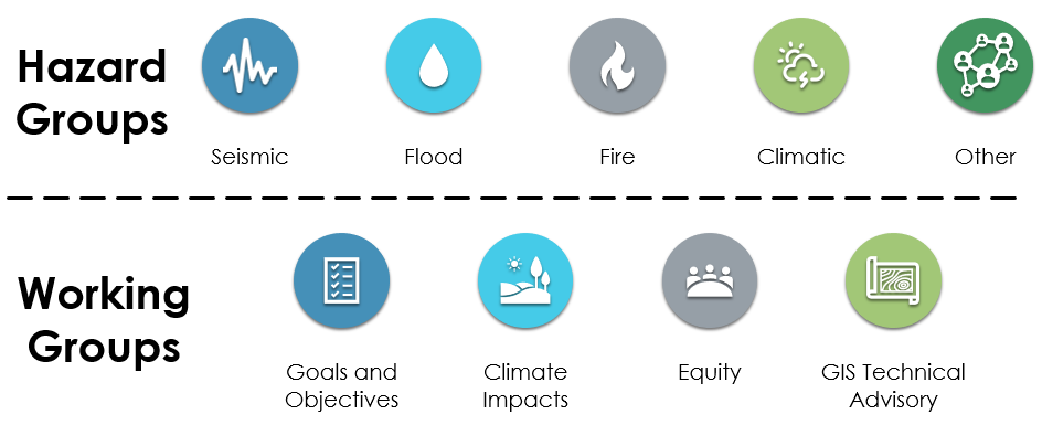
Hazard & Working Groups
The Hazard and Working Groups were essential to the successful 2023 SHMP update. These groups consisted of subject matter experts across the State of California and from all levels of government. Members provided suggestions about the most authoritative hazard data, hazard descriptions, and information about mitigation efforts statewide to bolster California’s resiliency.
The SMP Unit is adding a fifth Hazard Group: Climatic Hazards. This group will focus on the hazards of Drought; Extreme Heat; Extreme Cold or Freeze; and Severe Wind, Weather, and Storms.
During the 2023 SHMP implementation and maintenance phase, these groups advise on any major hazard developments, such as new authoritative data, changes to characterizations of hazards, or major milestones in addressing hazards by stakeholders.
The groups include:

Join Our Hazard & Working Groups!
If you are interested in joining a Hazard or Working Group, please contact the State Mitigation Planning Unit at SHMP@CalOES.ca.gov. Membership is open to any government, academic, Tribal, non-profit, or community-based stakeholder within California or that works in California significantly.

State Mitigation Planning Team

Victoria LaMar-Haas
Mitigation Planning
Division Chief
Victoria.LaMar-Haas@CalOES.ca.gov

Matt Muñoz
State Mitigation
Planning Unit Chief
Matt.Munoz@CalOES.ca.gov
| Matt Muñoz | Matt.Munoz@CalOES.ca.gov | Senior Emergency Services Coordinator |
| Ryan Marth | Ryan.Marth@CalOES.ca.gov | Emergency Services Coordinator |
| Aykanush Mikayelyan | Aykanush.Mikayelyan@CalOES.ca.gov | Associate Governmental Program Analyst |
Join our HM Grant Distribution Group!
Sign up here to get e-mail updates on Hazard Mitigation Grant webinars, funding opportunities, and more.


